Summary

Hamilton City Council manages growth in the city. Part of this means guiding where we grow so it's in the right places with good transport connections, close to all the things we need and considers the impact on the environment. Our Hamilton Urban Growth Strategy guides how and where we do this.  

Our water, wastewater and stormwater networks are fundamental services required for growth. We’re experiencing some challenges with how much development our three waters networks can cope with in some local areas. We have plans in place to deal with these challenges and have planned and budgeted for strategic infrastructure upgrades and improvements required to support growth. However, there are steps we need to put in place right now to protect our environment while our investment programme catches up.

Wastewater Capacity Viewer

This viewer shows users where there is capacity in Hamilton’s wastewater network to support development and where there are capacity limitations.

You can use the viewer to check the wastewater capacity status of individual properties across Hamilton.

We will update the viewer periodically as new data become available. 

Wastewater Capacity Viewer


What's the situation now?

Our water, wastewater and stormwater infrastructure were built to cater for a certain type of development in Hamilton at standards appropriate at that time.

Since then, there is new legislation and higher environmental standards that our infrastructure networks must meet. This includes stronger obligations to restore and protect the wellbeing of the Waikato River set out in Te Ture Whaimana o Te Awa o Waikato: the primary direction setting document for any activity that affects the Waikato River.

As we have grown into a much larger city more people are living and working more closely together but being serviced by infrastructure built to previous standards which at that time weren’t designed for our current growing population.

While Council does have an investment programme to upgrade our infrastructure to meet the new requirements and allow for growth, our modelling and monitoring shows parts of our city have capacity constraints right now. In some of these older areas we’re already seeing the impact particularly following wet weather events.

What areas are we talking about?

Our older areas of the city are impacted the most. We have identified specific areas that are high-risk based on: 

  • network performance following wet weather events
  • infrastructure modelling.

High-risk areas currently have limited or no capacity in the network for development without the completion of upgrades to provide the extra capacity. 

Use our online Wastewater Capacity Viewer to find where there is capacity in Hamilton's wastewater network to support development. 

Wastewater Capacity Viewer

Our highest risk areas right now are: 

  • the south-west (such as Bader, Melville, Deanwell, Glenview, Fitzroy)  
  •  parts of Hamilton East, Claudelands and Fairfield
  • parts of Hillcrest and around the University
  • other isolated pockets of the city including small areas of St Andrews, Rototuna and Nawton.

Wastewater capacity in Hamilton

This map shows where there is capacity in Hamilton’s wastewater network to support new housing and where capacity is constrained.

This map is indicative only. Please do not use it to assess wastewater capacity at a property level.

We will update this map regularly. Click on the map to open it as a PDF. 


Rotokauri

Council has constructed strategic wastewater infrastructure to enable about 8500 homes for 21,000 people over the next 50 years.

Ruakura

Council and developers have invested in strategic wastewater infrastructure to enable about 1600 homes for about 4000 people over the next 40 years. This infrastructure has also enabled the development of the Ruakura Inland Port and industrial and commercial land in the area.

Peacocke

Council’s ongoing investment - in partnership with central government’s Housing Infrastructure Fund investment – will provide strategic wastewater infrastructure to enable about 7400 homes for up to 20,000 people over the next 40 years.

Central city and surrounds

Council has prioritised this area for housing intensification. Council investment - in partnership with central government’s Infrastructure Acceleration Fund - will be used to plan, design, and construct strategic wastewater infrastructure to enable 4000 new homes for around 10,800 people in the central city and surrounds by 2035.

Rototuna

Council has invested in strategic wastewater infrastructure that’s enabled 11,300 homes to be built, with remaining developable land providing another 2000 homes for 5000 people.

Te Awa Lakes

Developer investment through an agreement with Council and a Private Plan Change will enable about 1500 homes. Further work is underway by the developer to enable an additional 1000 homes.

  • Further investment is needed by developers and Council over the coming years to fully unlock development in Rotokauri, Ruakura, Peacocke, Rototuna and the Central city and walkable catchment.
  • Greenfield areas are places where new suburbs or developments are planned. Brownfield areas are parts of the city that are already developed but still have space for more housing or businesses.

What does this mean for developments now?

Council encourages developers to contact us early about development in high-risk areas so developers can make informed commercial decisions regarding the prospect of a service connection.

Capacity constraints will be an important factor in Council’s assessment of resource consent applications and three water connection applications.

1. For new developments

For new development proposals where a resource consent or building consent has not yet been applied for, in high-risk areas, we will consider the infrastructure needs and likely advise that service connections will not proceed until our investments can ease any capacity issues.

If a resource consent application has been lodged and accepted for processing in a high risk area, Council will assess the impact of the development on the three waters network as an environmental effect. This assessment will be an important factor in whether a resource consent application will be notified, approved or declined.

So, what is Council doing?

Revising our Connections Policy – Managing growth in the interim

We’re currently reviewing our connections policy to make sure it’s as responsive as we need it to be to help us manage our networks. We’ll be talking to iwi, mana whenua and the development community more about this as the revised policy is drafted and there will be a full public consultation process.

Connections approvals are a legal mechanism under the Local Government Act (2002) and set out what requirements must be met for a new development to connect to our three waters networks.

Traditionally a granted resource consent would enable connection to the network, subject to certain standards and conditions being met, and development to proceed. Under our current policy there is an option for Council to decline a connection based on the impact on the network. This is not a tool that we have used before.

We don’t know the outcome of the connections policy review yet, but it is likely there will be a stricter criteria for new three waters connections in high-risk areas of the city until long-term infrastructure solutions are implemented.

Plan Change 12 – Changing the rules

As part of Council’s response to Government’s direction to provide more housing, and higher density housing, we’ve recognised we need to put additional mitigations in place to manage the effect on the city’s already constrained networks. These measures will help manage the impacts of higher density housing on our infrastructure and respond to our obligations to Te Ture Whaimana o Te Awa o Waikato. Plan Change 12 introduces provisions protecting our trees and gully networks, clear rules around permeable surfaces, on-lot stormwater management, rainwater re-use tanks and other measures to reduce the impact of development on the network.

The plan change also identifies the areas in the city where Council is prioritising higher density development. Rather than allow intensification anywhere, Council is focusing intensification in the central city and its immediately surrounding areas by setting the rules so it's easier to develop here than in the rest of Hamilton. Alongside these provisions, Council will be prioritising its infrastructure spend in these areas, so that additional capacity is made available to match the level of residential intensification. These measures will sit side-by-side with the revised connections policy.

Learn more about Plan Change 12

Infrastructure investment programme – The long-term solution

We continue to invest in our three waters networks. We can’t upgrade everything all at once, so we’re prioritising our investment to address existing system capacity constraints and meet future growth demands in our priority areas. This will mean that investment in other areas of the city will not be prioritised or publicly funded. Infrastructure capacity constraints may limit growth in those areas.

Investment is a long-term solution. As we invest, pressure will be eased in high-risk areas – but often there are a suite of investment that is needed to address capacity and performance challenges which takes time to implement. For example, over the last five years we have invested in new and upgraded wastewater interceptors, trunk mains, pumpstations and flow diversion which have improved our system performance and eased network pressure across the city including in the west, east and the central city.

We want to provide developers with as much certainty as possible and help deliver new housing for the city while also protecting the Waikato River. We have a programme of work in the central city - supported by the Government’s Infrastructure Acceleration Fund (IAF) – to invest millions of dollars in water and wastewater infrastructure. Over the coming years, more than $200 million will be invested into our central city’s water systems which will support growth and help unlock new housing. This investment includes funding for a new 25ML water reservoir and a pump station as well as wastewater upsizing and improvements.

Council has recently revised its Hamilton Urban Growth Strategy, which outlines priority areas in the central city and surrounds, along transport corridors and in greenfield areas. This will help us prioritise our infrastructure investment programme. We have an Infrastructure Strategy which sets out a 30-year investment programme to inform decision making. Currently, how, and when that investment is prioritised is decided by Elected Members, in consultation with the community, through the Long-Term Plan process.

Future investment programmes will prioritise the strategic infrastructure needed to service the central city. Developers will be expected to contribute toward or fund trunk and local infrastructure needs.

Planned investment in Hamilton's wastewater network

Click on the map to open it as a PDF.

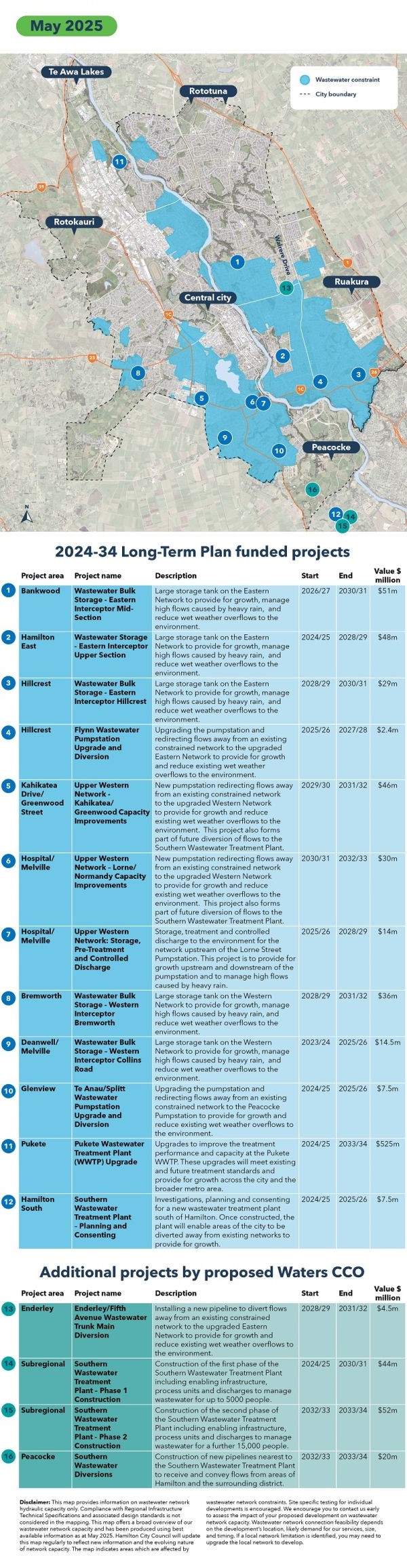
Wastewater network constraints in Hamilton after 2024-34 Long-Term Plan investments and proposed Waters CCO's investments

Click on the map to open it as a PDF.


Frequently asked questions

What is a wastewater constrained area and where are they?

A wastewater constrained area is an area where the pipes that carry wastewater are already full or nearly full during and following heavy rain and adding more homes or buildings could cause or worsen existing overflows. Untreated wastewater overflows to the environment are prohibited in the Waikato Region. They are bad for the environment and the Waikato River and increase public health risks. The mapped blue areas generally show the areas affected by wastewater constraints.

How do I know if I am in a constrained area?

Where a property is clearly within the blue-coloured constraints area of the map, then it is affected by wastewater constraints. If an area is close to the boundary of the blue-coloured area, we recommend you contact Council at info@hcc.govt.nz to confirm.

Where can I develop?

The green areas on the map show where there’s enough capacity in the wastewater system to support more homes and buildings. This includes both new development areas (greenfield) and already built-up areas (brownfield).

  • Greenfield areas are places where new suburbs or developments are planned. Council has already built important wastewater infrastructure in four key areas:
    • Peacocke
    • Rotokauri
    • Ruakura
    • Rototuna
  • Brownfield areas are parts of the city that are already developed but still have space for more housing or businesses.
    Council is also focusing on upgrading pipes and systems in the central city and nearby neighbourhoods (within an 800m walking distance) to support more people living there.

    We recommend you contact Council at info@hcc.govt.nz to discuss your proposal before starting an application to develop.

If my property is in a green-coloured area, does that mean I can develop it?

Yes. However, the map is only an indication of where wastewater network capacity exists and where wastewater network capacity is likely to be constrained. The map identifies network capacity at a suburb level and some individual streets within suburbs identified as having capacity may be limited due to bottlenecks in local wastewater pipes. The extent of local network constraints will depend on the development’s location, size and likely demand for our services. If a local wastewater constraint is identified, the developer may need to upgrade the local network before developing their property. Council currently has limited funding to resolve local network constraints.

Why are some development proposals being turned down?

Not all parts of Hamilton have the capacity to handle more homes or businesses right now. Some areas, especially older parts of the city, already struggle during heavy rain, and adding more development could make things worse.

While Council is working on upgrading the infrastructure, we have to be careful. We have legal and environmental responsibilities to protect the health of the Waikato River. That means we need to manage new connections to the wastewater system to avoid more overflows.

What is Council doing about wastewater capacity issues?

Over the past 10 years, Council has made major upgrades to the wastewater system — adding capacity to the Pukete Wastewater Treatment Plant, adding new pipes and pump stations, and building emergency storage. Council’s Long-Term Plan has budgeted $1 billion for wastewater system upgrades. These upgrades help support growth and protect the community, especially during heavy rain.
But we can’t upgrade everything at once, so we have to prioritise where we invest. Right now, the focus is on:

  • Supporting new homes in greenfield areas like Peacocke and Rotokauri.
  • Upgrading infrastructure in the Central city and nearby areas (within 800m) to support more people living closer to the city.

This balanced approach helps manage growth in a way that’s good for people and the environment. 

When will upgrades happen so I can move forward with my development?

Council is working on a plan that shows when upgrades are happening. This will be available online by June 2025. In the meantime, contact us to find out what’s planned in your area. If upgrades are happening soon, you may be able to get consent with conditions – meaning you could get approval now but can’t connect until the upgrade is finished.

In a constrained area

My development is allowed under the District Plan. Can I proceed?

Even if your development is permitted, Council still has to approve any connection to the wastewater system (under the Trade Waste and Wastewater Bylaw 2024 and the Three Waters Connection Policy 2020). If there’s not enough capacity, your connection may be declined.

We recommend talking to us before going further.

Future solutions

Can I use alternative solutions to address a constraint if the upgrade is years away?

Some solutions can be more complex and carry higher risks. If you wish to pursue a different solution, Council will need to assess if that solution is viable. You will need to collaborate with Council and meet strict approval, design, and operating requirements.

Council won't allow wastewater tankering (collecting and transporting wastewater using trucks) or off-peak pumping.

Share this page

Feedback

Has this page been helpful?
Thanks for your feedback.

Last updated 30 April 2025